
It is in this part of the site that the main track that pilgrims follow from St Jean Pied-de-Port to Santiago is described. The stages are therefore described in chronological order.
Have a good trip.
Camino francés from St Jean-Pied-de-Port to León
We cannot start on St James’s track, called Camino francés, without having tried to clarify, as much as possible, this muddle that has created today the Compostela fashion. Today, nearly 350,000 pilgrims come to Santiago every year. In the Middle Ages they were even more numerous. They are talking about one million a year and demographics were less galloping than today. Then, there was a real decline. Before the 1950s, it was said that they were only a few hundred a year on the way. But how was this story born? According to legend, the remains of Saint James have been transferred from Jerusalem to Santiago. Following the discovery of the supposed tomb of the Saint in the IX century, the pilgrimage became the true way, allowing the pilgrims to receive the plenary indulgence, a total forgiveness of the sins, a real bargaining which was one of the causes of the appearance of Protestantism. Now, for the good of things, the pilgrimage has made it possible to constitute a real heritage. The churches, the hospitals, the places of accommodation, the bridges, all that is due to the pilgrimage. And this is even more true in Spain. And recently everything changed again, when the Camino Frances was certified “Cultural Route of the Council of Europe” in 1987. When you leave St Jean-Pied-de-Port in the early morning, the biggest surprise is the stream of pilgrims advancing on the Camino francés. If you have crossed France by the Via Podiensis, it is actually a shock. You will probably never walk alone again, or else you will have to choose a timetable or a breakdown of the stages different from that used by the mass of pilgrims. More and more pilgrims, wishing to find a little more calm, less incessant chatter on the routes, are using this stratagem.
When you follow the Camino Francés, you will travel exclusively to the northern regions, passing through Navarre, Rioja, Castile and León and Galicia. You will probably be surprised after having crossed France. The Camino Francés is a completely different route. If during the first week, the landscape looks rather like that of the French Pyrenees, thereafter it will be for a long time the Meseta, most often along the great plains of cereals. It will be necessary to pass León to find the real hills, in Galicia.
The journey begins with the so fantasized scarecrow of the climb to Roncesvalles. And yet, many pilgrims will be amazed at how easily they crossed it, after having sounded the horn, as the legendary Roland did. This opens up all horizons for them to cross long Spain. From Roncesvalles, it is then a fairly substantial crossing of the Pyrenean reliefs in the beautiful beech and pine forests of Navarre, along magnificent villages made of colorful and emblazoned houses. Quickly, the shaded tracks of the Arga valley lead you to Pamplona, the capital of Navarre, an open-air museum. Further on, the plain is dominated by the Del Perdón hill and its wind turbines, to arrive at Puente de la Reina and its magic bridge over the Arga River. Here, the Navarre Way and the Aragonese Way merge to become the Camino Francés. There was a time when the route was not really defined. It was in the XIth century that Sancho III the Great, King of Pamplona, encouraged travelers to take the route we know today. Then comes the first meeting with the highways and the main national arteries which will accompany you for a long time on the course. But on the route, you will find very beautiful villages and large towns, such as Estella, an ancient capital of Navarre, which is full of gems. You then enter the Meseta, this immense cereal plateau of northern Spain. The tracks get lost in this kingdom of solitude. Shortly beyond Los Arcos, after 150 kilometers of walking, you leave Navarre for La Rioja, entering the beautiful and old town of Logroño, its capital. In Rioja, vineyards as far as the eye can see await you, but also the dreaded N-120, the region’s main road, which unfortunately cuts through a Mesata which is lost between vineyards and cereal crops. Along the way, Nájera and Santo Domingo de la Calzada are real treasures. Beyond Santo Domingo, the last Rioja vineyards undulate towards the province of Burgos, Castile.
The harsh and monotonous landscape of Castile defies the walker who always follows the N-120 road. Fortunately, there are the Monts d’Oca under the holm oaks which once sheltered thieves and wolves. Beyond Atapuerca and its prehistory, you can already see Burgos and the towers of the Cathedral of Santa Maria, a marvel of Gothic architecture, perhaps the most beautiful cathedral in the world. Beyond Burgos, the Meseta, the harsh plateau of Castile interspersed with cereal valleys, resumes its rights as far as León. It’s long, very long under a blazing sun, or under the rain and the cold of spring. Even the Templars, and later the armies of Napoleon, found it difficult to cross this austere solitude, that says it all.
Beyond León, you will read more in the second half of the trip to Santiago
But before embarking on the journey, it is good to say two words about a famous book, but often quite unknown to pilgrims, the Codex Calixtinus.
Codex Calixtinus
Let us try to understand this decision, which was somewhat a godsend. The codex Calixtinus, also called Liber Sancti Jacobi was written between 1130 and 1140. At that time all was oral transmission and the pilgrims who returned to the country told their pilgrimage. But there was a need to codify all these stories, to fix in a certain way these knowledges coming from orality. This gave birth to Book V of the Codex, the Pilgrim’s Guide, one of the chapters of Liber Sancti Jacobi. This manuscript was extensively reworked, completed, copied, but the “most true” manuscript is that deposited in the archives of the cathedral of Santiago and which is designated under the name of Codex Calixtinus, of the name of Pope Calixtus II who would have initiated the writing. In the Middle Ages, books are rare. They are only created on parchments by the copyists of the monasteries. In many documents, the copyists added illuminations, to be admired by a general public belonging to the elite. So was the Codex.
The appellations of Codex Calixtinus, Liber Sancti Jacobi, are not original, being recent, made in XXth century. In the past, this manuscript was simply called Jacobus. Over the centuries, the scribes of the monasteries have deeply reworked the manuscript, destroyed pages, added others, with about ten different versions. What remains of the original, the authentic? It must be understood that it is a true work of archaeology that historians must do to delve into this complexity of copies, to find good sheets, good tables of material, to override the preferences of monasteries or archives that still have these copies, all over Europe. In fact, many abbeys have sent their scribes to copy parts of the manuscript. This is not always bad will but the history of the codex is a real confusion, political too.
The Liber Sancti Jacobi contains 5 chapters. For the pilgrim who walks, the first 4 chapters do not offer much interest. The first book is the longest book of the codex. This book deals with sermons, how to hold the service, to sing for the festivals in honor of St. James. The second book deals with the 22 miracles attributed to the saint. The third book relates the removal of the remains of the saint of Jerusalem to Santiago. The fourth book narrates the epic of Charlemagne and Roland facing the Moors, with the help of the saint. Then, what about Book V, the guide of the Pilgrim? This was the first section of the Liber that was translated into French by Jeanne Vieillard, a translation that was a resounding success, which was for many in the attribution of the Way of Compostela to the UNESCO World Heritage. This book tells the way, a number of stages, places. But it’s a great wave. It is this book that has given rise to the most fantasies, the greatest fantasy having been to attribute, without any proof, this chapter to Aymery Picaud. Internet is full of “fake news” about it. Spanish people went head down to ensure the veracity of their way. It was wrongly developed the idea that this manuscript was used by the pilgrims of the middle ages, whereas this guide is known only since the end of the XIXth century, and especially after its French translation in 1938. This book and all the copies made of them never came out of the abbeys and their archives.
It seems well accepted, but it is not certain, that the codex was developed for reasons of faith. It was necessary to reform the sclerotic liturgy, to dust it off, to endow Christendom with a set of sacred texts. This was the message of Calixte II. We know today that the scribe of chapter I had close ties with Cluny Abbey, in France. In fact, Pope Calixtus II was born Gui of Burgundy. This Cluniac and Cistercian pope was therefore Burgundian. Before becoming pope, he had, by trickery, received the archbishop of Compostela granted by the pope in place. This fact takes place a few years before the drafting of the Codex. And it is at this time that a certain Aymeric Picaud presents himself to Santiago, coming back from a pilgrimage to Jerusalem. An important question is why St James, and not another apostle, was the object of devotion? James the Greater is the poor relative of the trio elected by Jesus, namely Peter, John, and James. Peter was entrusted with the Church and Rome. John was to evangelize the East. For Jacques, there is nothing specified in the Bible. But the mission of all the apostles was to go evangelize the world “finis terra”, to the end of the world. Was it inferred that it was necessary to go to Finisterre in France and Spain? According to legend or tradition, James the Greater would have gone to Spain to spread the new faith. He would have converted only a very small number of people. Back in Palestine, he would have been martyred. His friends would have brought the body back to Spain. After centuries of oblivion in 831, a hermit named Pelagius discovers by divine revelation, under the form of a star, the place of burial near Santiago. The religious and secular authorities hasten to authenticate the discovery. Compostela was born. The pilgrimage to the apostle’s tomb is enjoying increasing success, a growth temporarily interrupted by the sacking of the city by the Muslims, who left the tomb intact. The city was rebuilt and the pilgrimage started again
Thus, in an unproven historical context, on an ambiguous saint of which neither the New Testament nor the historians know much, a true myth has been created. And that by the magic of the Cross, Santiago was created. It was therefore a good solution to codify all that. So, who wrote the Codex Calixtinus? Aymeric Picaud, the pope or some others? Nobody knows anything about it, really. Francophones speak for a French. Why? Because the author of the Codex Calixtinus often despises Spanish people, for whom he finds full of malignity and depravation, while he brings the French to the skies. The major reason is that the author speaks of 4 French roads and only one Spanish road. But, all this is not just nonsense? In the past, and still today, the roads were numerous, and if today their official number is reduced, it is due to the total and probably political incompetence of UNESCO and the Council of Europe, that have relied only on the Codex to normalize the thing. What childishness for a historian! If the author describes mainly French tracks, much better than Spanish routes, it is undoubtedly that he has travelled much more in France than in Spain. Moreover, half of the miracles attributed to the saint have been performed in France. Clear conclusion: the author is French, not Spanish. Of course, isn’t it? Do yourself your opinion on this. If you are French, we already know your answer.
The Liber Sancti Jacobi is a deeply religious work. It is therefore likely that the author or authors were churchmen, or that they were helped in their approach. Is it then the enigmatic Aymeric Picaud, a French priest from Poitou, quoted twice in the Codex? The latter, who is the author of a hymn in the second book, transported the Codex Calixtinus from Vézelay to Santiago. So, it had to be an important person to have the right to touch the book. But, even if the author of the code speaks of Poitou with tenderness, does this justify that this priest has written the code? Whether it was written by a single author or a compilation of older texts, the book, by historical cross-referencing, was written between 1139 and 1164. And in Latin, to be fair. Imagine the dozens of translations of the Bible, and you’ll get a better idea of the Codex Calixtinus..
So when you’ll be walking on the Camino francés, remember this story, if you think you’re walking on what Spain calls the “real way”, while the French cry because they did not create them also a “real way”. It would have been much simpler, a long time ago to find a tomb of St Jacques in France, and the trick would have been played.
Statistiques de fréquentation des Chemins en Espagne (2018)
The Santiago Registry Office provides statistics on the attendance and distribution of pilgrims on the way each year. In recent years, because of the Covid, attendance has of course decreased. Here are the 2018 data recorded according to the origin of the pilgrims, for the 15 most represented countries. This is the most comprehensive statistic in recent years.
| Country | Number of pilgrims | Country | Number of pilgrims |
| Spain | 144’141 (44.03%) | South Korea | 5’665 (1.73%) |
| Italy | 27’009 (8.25%) | Brazil | 65’601 (1.71%) |
| Germany | 25’296 (7.73%) | Australia | 5’220 (1.59) |
| United States | 18’582 (5.68%) | Canada | 5’027 (1.54%) |
| Portugal | 14’413 (4.4%) | Poland | 4’785 (1.46%) |
| France | 8’775 (2.68%) | Holland | 3’670 (1.12%) |
| England | 7’624 (2.33%) | Mexico | 3.578 (1.09%) |
| Ireland | 7’548 (2.31%) | ||
| Total number : 327.378 | |||
Spain provides the big battalion of the way. Beyond the 15th country, all others are below 1%. We also know that there are as many women as men on the way and that 55% are between 30 and 60 years old.
Another interesting statistic is the one that gives the figures for the track used by pilgrims to reach Santiago.
| Track | Number of pilgrims |
| Camino francés | 56.8% |
| Camino Portugués | 20.7% |
| Camino del Norte | 5.8% |
| Camino Primitivo | 4.6% |
| Other tracks | about 15% |
It is often believed that all pilgrims arrive in Santiago by the Camino francés, the track of Codex. This is not the case. Only half of the pilgrims uses this axis. It must be remembered that many Spanish, Portuguese and South American people use the other tracks of Spain and Portugal. So, are these tracks fake tracks? We will never get out of this confusion that was the decision of the Council of Europe.
A final statistic shows the departure place of the pilgrims
| Starting place | Number of pilgrims |
| St Jean-Pied-de-Port | 10.05% |
| Roncevaux | 1.69% |
| Oviedo | 2.69% |
| Porto | 8.2% |
| Sarria | 27% |
The table shows that only a minority of pilgrims arriving in Santiago made the whole of Camino Frances (12%). The bulk of the pilgrim battalion on the Camino francés leaves from Sarria, shortly before Santiago. Just a few steps to get the certificate in Santiago.
Important note on mileage
It is very difficult to specify with certainty the slopes of the routes, no matter what system you are using, GPS watches or mapped profiles. There are few sites on the Internet that can be used to estimate slopes (three at most). Since these programs are based on an approximation and averaging around the desired point, there can be large variations from software to software, due to the variation between two points (e.g. depression followed by a very close bump). An example? On GR36 track, along the Breton coast, the altitude is rarely higher than 50 meters above sea level, but the route continues to climb and descend all day. For a course of about twenty kilometers, a software will give 800 meters of slope variations, another 300 meters. Who is telling the truth? For having done the course several times, the legs say that the difference in altitude is closer to 800 meters! So how do we do it? We can rely on the software, but we have to be careful, take averages, ignore the slopes given, but only consider the elevations. From there, it is only elementary mathematics to deduce the slopes, considering the altitude and the distance traveled between two points whose altitude is known. This is the way of doing things that has been used on this site. Moreover, in retrospect, when you “estimate” the route calculated on the basis of the cartography, you notice that this way of doing things is quite close to the truth on the ground. When you walk often, you quite quickly have the degree of tilt in the eyes, and especially in the legs.
But there is more to this. The programs that allow you to calculate height differences lack precision for relatively flat routes, often not considering small variations of less than 2 meters. Therefore, and especially for sections with less than 5% gradient, you will have the feeling that it is almost flat, but this is not always correct. It can slope up and down often imperceptibly. But your legs are registering all of these movements. So, to be closer to reality, add 100 to 200 meters of elevation gain and loss for most of these stages. Some GPS watches that continuously record the path will also tell you the same. But here, too, GPS is not the precision of a Swiss watch.
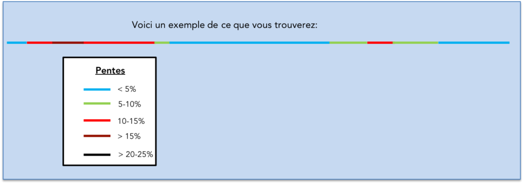
We understand the difficulty of the exercise. Having made the experiment several times with two different GPS, also giving the altimetry, we can sometimes find a great variation in the level of the indicated altitude. The only true figure is that given by the contour lines of the official maps of the states. But, this should not spoil your pleasure in any way, even if you are given figures that will be said to be approximate, but no doubt quite close to the reality on the ground. In the graphics, it is enough to consider the color to understand what it means. Light colors (blue and green) indicate modest slopes of less than 10%. Bright colors (red and dark brown) show steep slopes, with brown exceeding 15%. The most severe slopes, greater than 20-25%, very rarely more, are marked in black..
Marking of tracks in Spain
The signage of the Ways to Compostela varies according to the territories crossed. If you have crossed France, you are very accustomed to the red and white marks used for the Chemins de Grande Randonnée, the GRs. But, in Spain, the Camino Francés does not follow GR. The route is extremely well signposted. First there is the famous stylized scallop shell on a blue background. This logo is available in shells on terminals along the route, but sometimes also on shells nailed to the ground, in the cities of Spain. You will easily recognize them. Watch out here! In Spain, they only tell you that you are walking the Camino de Santiago. They do not necessarily tell you the direction to follow. The directions are given by the yellow arrows painted on the ground, on rocks, on trees. They are the main markup in Spain and Portugal
 |
 |
What you’ll find in the site
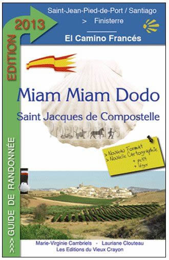
To aid in route planning, the route has been divided into arbitrary units. Everyone walks in their own way. For each stage, you will also have accommodation options available. We cannot ignore the existence of Miam Miam Dodo, whom many consider to be the bible of the Camino de Santiago. Our site is very complete in addresses, but does not give accommodation outside the track, which Miam Miam Dodo does, which also has the undeniable advantage of being updated every year.
 |
To start your course in Spain |